
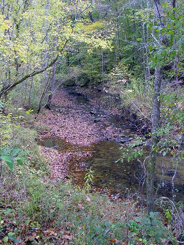
All the water on our place drains into a creek that runs through the property. We had a very dry fall, but the creek still flowed, at least a little.
Once it started raining again, it rained more than usual, and as a result the weathermen say we're back up to "normal" for the year. (Somewhere around 55 inches or 140 cm.)
Here's the creek yesterday, after several inches of rain the day before:

By today it'll probably be back somewhere between those two extremes.
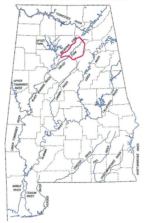
Here's the big picture, showing all the major rivers in Alabama: I've somewhat shakily outlined our county in red. You can click on any of these for a larger view.
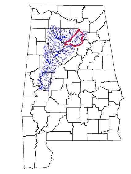
Here it is with only the Black Warrior River shown, including all its forks, tributaries and feeders. Most of the water in Blount County eventually drains into the Black Warrior. (Exceptions here.)
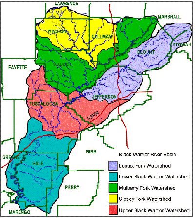
It's the Locust Fork that's our watershed. There are supposed to be 15 sub-watersheds, but I haven't been able to find a list online. Our little creek drains into the Blackburn Fork (a Locust Fork tributary).
Locate your watershed
The bigger picture:
South Atlantic-Gulf watershed
The really big picture:
Regional watersheds
I found a watershed lookup for Canada too, but it doesn't seem to be working. If you know of any good links feel free to post them in the comments section.
Local links:
Alabama Rivers Alliance
Friends of the Locust Fork
Beautiful photography of the Locust Fork from The Kingfisher Editions by Beth Maynor Young

16 comments:
The Ontario Ministry of Natural Resources has an excellent 'watershed' site at: http://www.mnr.gov.on.ca/mnr/water/watershed.html
including maps, tutorials,etc.
I love looking at pictures of your creek. Fantastic post on your watershed. Lots of great information. Thanks for all that work.
Wow - that is great; a lot of work! I love the way the streams and creeks come together like a net. I'm going to have to look closely at a couple of those websites, which I have not seen.
Your creek is really beautiful - ours just gets muddy and brown when it gets swollen. Sometimes even when it isn't. I got some great raccoon and coyote tracks photographed the other day though; and a possible bobcat track.
I've been debating about whether to have the creek water tested to see what the problems are, if any, as a stewardship sort of thing. I don't imagine it's free :-)
Wow - what an amazing piece of work! I wish I could reciprocate. I mean, we have water. There's a creek but from whence it comes and where it goes are kind of opaque issues for me.
Great pictures. You did do a lot of work and I intend to check some of those links out as well.Interesting! Thanks!
The creek is just so cool..
Thanks, that probably was a bit boring for most people... I geekily have to admit that we knew most of that info already... We had a neighbor with an old, old septic tank system. Long story short, they were dumping the raw stuff into a drainage ditch that ran down our way. (Lovely!) So we did a lot of research at that time. (The Health Dept ended up helping us with that problem.)
Wayne ours gets muddy sometimes too but the recent rain was a steady all-day slow rain instead of a downpour, so that might be why it wasn't brown this time.
Marsha, I was able to look on a topo map (topozone.com) to figure out where our creek comes from and where it goes. It's easier if you have a big relief map but you can usually follow it on the computer too.
Wayne yeah I'd love to have our water tested too but don't even have any idea how to go about it. There's not a ton of stuff upstream from us, but you never know what the people just up the road might be doing! One day we noticed the creek get all muddy for no apparent reason. Figured someone upstream had to be doing something, but never did figure out what. The downstream neighbor's cows drink from this creek, and I'm sure they deposit stuff in it too. :)
This is some neat stuff. Before we moved here to God's country we visited a lot. Coming down I-81 we would pass a sign saying we were leaving the Chesapeak Bay watershed and entering the Gulf of Mexico watershed and I knew we were almost there (here).
No creeks on out property but I've posted about the one that's spring fed down the trail at the end of our road. It's a little sanctuary spot.
THIS is great! Great stuff. I have to go over to Wayn'es, too but this is a discussion I want to take part in (esp. as I am very proud of our little part of the watershed).
You did a beautiful job of explaining and illustrating your creek and it's place in the bigger picture. As nerdy as it sounds, if people knew more about their own watersheds I suspect that knowledge would be reflected in water quality.
Can I link to your site? I have one post to do first but this weekend I'll be out at the lake so you've inspired me! I'm back to re-read yours once more and then off to Wayne's.
I contacted our County Ext. office because I want to have our spring tested to use as drinking water for our house, and they referred me to the Health Dept. A Mr. James Kelley is the man to speak to and they say he is in his office in the afternoon. He is out and about earlier in the day checking complaints etc. thats why he doesn't come in until later. I haven't had time to go down there yet so I don't know more about what to do. But he's real nice.
Wow, I'm impressed over the work you've done with this post!
Great to know information, especially for us who lives in Sweden. I'ts always interesting to learn about other countrys.
Well done :-)
Good job. I get water testing gear from Wards Scientific. My students do some basic water testing of our closest stream.
Weldergirl, that's who we've talked to there. He is very nice.
Anyone else who wants to write about their watershed, go for it! :)
Great site...you can use a tool from the EPA for watershed and stream info. www.epa.gov/waters/enviromapper/
(click on the map to get it going)
We live up on Highland Lake (the part of the Blackburn Fork that they dammed).
Hey thanks George! I'm going to have a lot of fun playing with that. :)
You are not far from us!
A friend and I are going to paddle the upper Blackburn (from Benedicts/CR27 to Inland)sometime this spring (when there is water). Do you recall a guide for the section...I remember reading one but can not find it.
Post a Comment